East Athabasca Basin Projects
Grey Island
key highlights
LOCATION
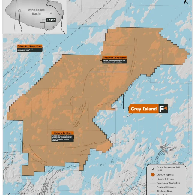
The project consists of 22 mineral claims totaling 47,912 ha. It is located 15km inside the southern margin of the Athabasca Basin, halfway between the Key Lake Mine and Cameco’s Centennial uranium deposit.
GEOPHYSICS
The Grey Island area has been prospected since the 1960’s and during the 1980’s, large-scale regional prospecting and airborne and ground geophysical surveys were conducted. The property is attractive due to several basement EM conductors situated within magnetic low corridors, often interpreted as structural corridors most of which have never been drill tested.
DRILLING
Only one historic drillhole has been completed and on the property by Titanium Uranium Inc. in 2008. Drillhole FLM-08-05 to test EM conductor “F” and intersected strong bleaching and clay alteration from 117.6 – 203.9 in the Athabasca sandstone. Basement in this hole encountered a pyritic, graphitic rock with 90% graphite locally. Conductor “F” was defined as being 7km long and due to permit restrictions forcing them to drill from the islands rather than from the lake resulted Titanium Uranium reported that “holes did not test the most interesting part of the conductors” and further exploration along the conductor was recommended. The depth to the unconformity averages ~270m on the property.
Uranium Exploration Potential
The property features key geophysical indicators: basement electromagnetic (EM) conductors within magnetic low corridors and adjacent magnetic highs. A notable seven-kilometer long ground EM conductor on the eastern portion of the property was tested only by a single drill hole in 2008 while the west and northernmost claims of the property contain multiple kilometers long, untested conductor complexes within magnetic lows with no reported historic drill testing. The single hole drilled on the property (FLM-08-05) showed strong bleaching and alteration within the Athabasca Sandstone and strong local graphite in the basement.


