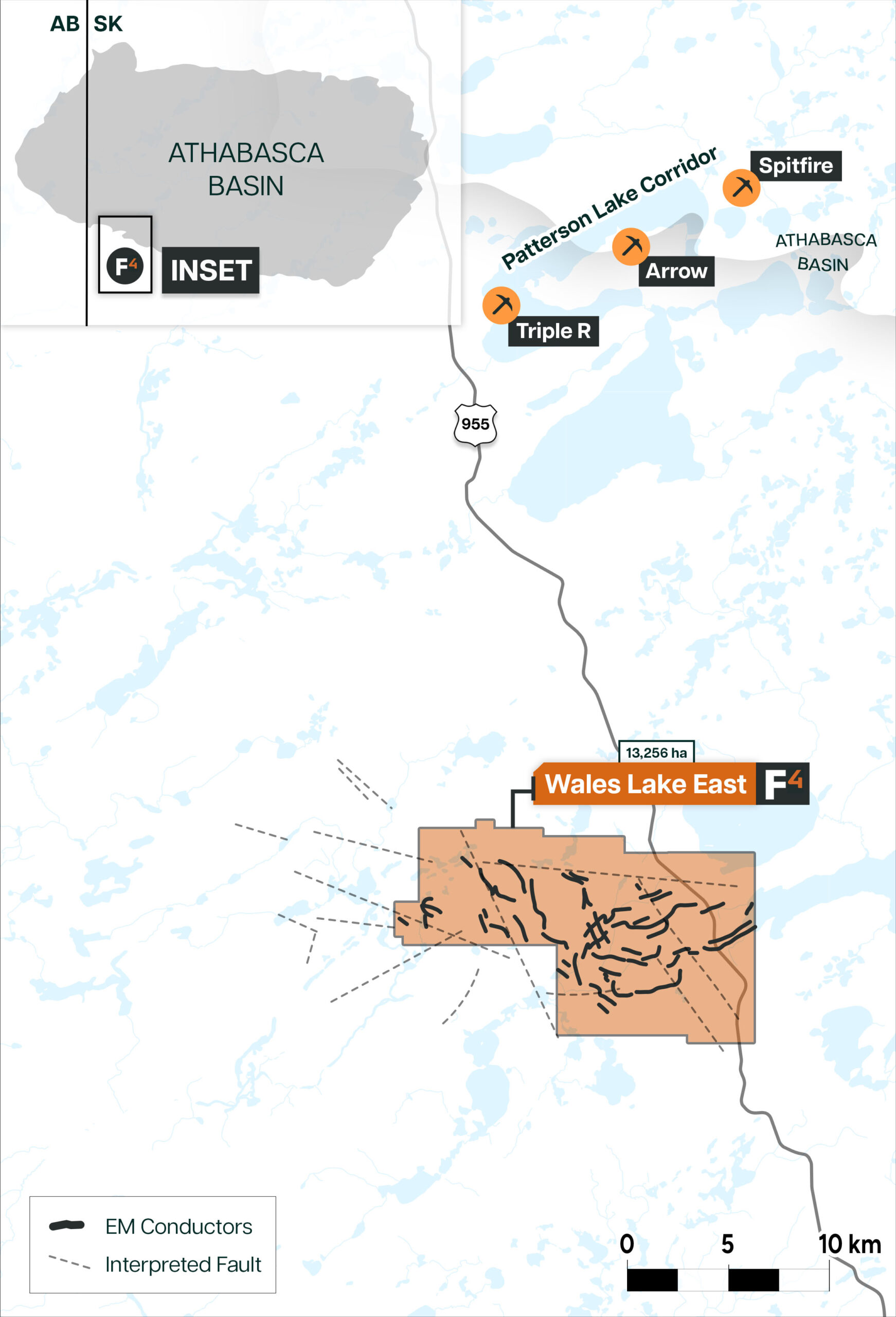


The Wales Lake East Property features 10 claims over 10,207 hectares. Highway 955 cuts through the east side of the property. The property is located outside the south-west margin of the Athabasca Basin and approximately 20km southwest of Paladin Energy’s flagship Triple R uranium deposit.
In July 2017 an airborne VTEM Plus survey was conducted over the western side of the property. Areas of conductance were followed up with ground based Small Moving Loop TEM In 2018 and 2019 to refine conductivity based drill targets. Promising results from the 2017 VTEM survey led to the rest of the property being covered in 2019. There are numerous areas of enhanced conductivity including features such as complex conductor swarms , multiple parallel conductors and many offsets and termination points indicative of possible cross structures.
One drill hole was completed in 2018 testing ground EM conductors. Hole WL18-00 intersected nearly 15m of strong graphitic alteration within sheared gneiss. Geochemistry showed slightly increased boron up to 310ppm. No anomalous radioactivity was encountered.
An airborne geophysical survey completed in 2017 resulted in numerous areas of enhanced conductivity, multiple parallel conductors, and various structural features like offsets and termination points as potential targets for future exploration. Follow up ground geophysics in 2018 and 2019 further constrained conductor targets. Targets identified by the ground geophysics programs remain drill ready.
The historic Wales Lake Property was split into Wales Lake East and Wales Lake West in order to allow for increased focus and opportunity on each property highlighting the increasing interest in the West Athabasca Basin for the potential for new uranium discoveries.
Dev Randhawa is a seasoned CEO with extensive experience in resources, mining exploration, and energy companies. As the former CEO of Fission Uranium Corp., Mr. Randhawa, along with his technical team, led the high-grade uranium discovery at PLS in 2012. Recently, Paladin Energy made an offer of $1.1 billion to buy Fission Uranium.
In 1996, Dev founded Strathmore Minerals Corp., leading it until 2008. Mr. Randhawa spun off Fission Energy Corp. in 2007, focusing on uranium exploration in Saskatchewan. He sold major assets to Denison Mines in 2013 for $85 million, creating Fission Uranium Corp.
Dev has executed significant joint ventures, including a $50 million partnership with Sumitomo (Japan) and $44mil with KEPCO (Korea). In 2016, Dev negotiated an $82 million investment in Fission from CGN Mining. He holds a BBA from Trinity Western College and an MBA from the University of British Columbia.